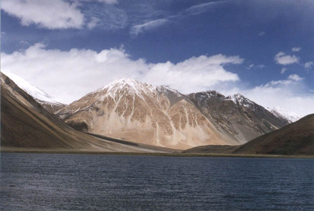
The Pangong Tso Lake is a long narrow basin of inland drainage, hardly six to seven kilometers at its widest point, and is over 130km long. The lake is situated at an altitude of 14,200 feet. One third of the lake is located in India, and the rest lies in China. Spangmik, the farthest point to which foreigners are permitted, is only some seven kilometers along the southern shore from the head of the lake, but it affords spectacular views of the mountains of the Changchenmo range to the north, their reflections simmering in the ever-changing blues and greens of the lake's waters. Above Spangmik are the glaciers and snow-capped peaks of the Pangong range. The uniqueness of Pangong Tso is in its water - it is brackish! It is the largest brackish water lake in Asia.
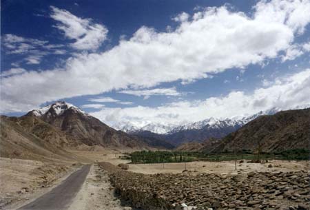
| The third day we woke up to an overcast sky, but at least it wasn't raining. We hired a taxi and rushed to the DM's office and got the permit for Pangong Tso and Khardung La. Since we planned to camp out in the night, we bought bread, cheese, biscuits, noodles etc. and also rented a couple of blankets and sleeping mats (there are lot of places renting out camping equipment at reasonable rates). By noon, we were on the way to Pangong Tso. This route took us past the picturesque villages of Shey and Thikse, and turned off the Indus valley by the side-valley of Chemrey and Sakti. | 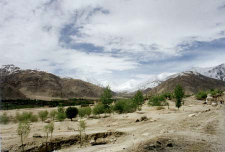 |
|
The approach to a Buddhist village is invariably marked by mani walls which are long chest-high structures faced with engraved stones bearing the mantra "Om Mane Padme Hum" and by chorten, commemorative cairns, like stone pepper-pots. Many villages are crowned with a gompa or monastry, which may be anything from an imposing complex of temples, prayer halls and monks' dwellings, to a tiny hermitage housing a single image and home to a solitary lama. |
| The roads in the mountains are generally very narrow, and the army has constructed Traffic Check Points (TCPs) to regulate the traffic. These TCPs are also equipped with recovery trucks to help any stranded vehicles. About halfway to Pangong, we reached the Zingral TCP, where we ran out of luck. We were told that there were three avalanches ahead blocking the road, and there was no chance of them getting cleared that day. Therefore, we had no option but to turn back. |  |
The fifth day's morning found us again heading for Pangong Tso. We started out early, we had to cover around 120kms to reach Pangong, and come back the same day. Good news was waiting for us at Zingral - the road ahead was clear!
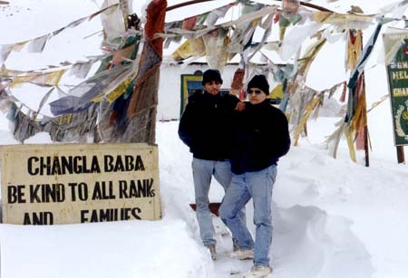 |
The Ladakh range is crossed by the Chang-la (17,220 feet) which despite its great elevation is one of the easier passes, remaining open for much of the year, even in winter, apart of periods of actual snowfall. The road beyond Chang La was in a very bad shape. Five-six feet of snow was piled on either side of the road, and we had to climb out of the taxi three times to push it through the snow piles. On the way, we passed through Tangse, which has cliffs for rock climbing. Tangse is also an excellent place for camping, and fishing enthusiasts can fish in the Tangse River flowing through the village. Beyond Tangse, we passed through the bed of a dried up river. There we saw a unique sight - a dust-snow storm! The valley was very narrow, and as a result, high velocity winds swept through it, picking up the fine sand deposited by the river. At the same time, these winds picked up the snow powder from the surrounding peaks, creating this unique storm! |
| Grins all around - the joy of finally making it there! We reached Pangong Tso around noon. The beauty of the lake was mesmerizing. It had crystal clear, calm waters, and the color of the water kept changing, depending on the angle you looked at it. The shores of the lake were white with the salt deposited by the lake's brackish water. The reflection of the surrounding peaks in the water was an enchanting site. We stayed in this paradise for about an hour, and then headed back for Leh. | 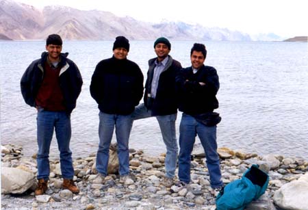 |
Copyright (c) Manish Tripathi , 1998. All rights reserved